TUESDAY EVENING UPDATE/DISCUSSION
NOW, ONTO THE STORM - In terms of the models, THERE WERE ALOT of problems with this storm, and its complexity and size...the MAIN issue was the warm air. None of the models saw it coming (Except the NAM) and what "it" was, was the fact that the storm was able to bring that warm air ALL the way north past Albany, West to Ithaca, and North to Portland, ME...This created a much bigger rain/ice event then expected, AND cut down those snow totals for many areas. Storm ALSO shifted EAST, causing the heaviest precip to move more OVER US, instead of Interior NY, NJ, and west of us.
SO, Otherwise, however, the system behaved as expected - NOW, WE STILL HAVE 2/3 MORE DAYS OF IT....ON AND OFF.
Now, I am happy that I can say I pointed this out a week ago when the storm initially came onto the models, and Dillon and I were in agreement with this, even as the system came through today - The REAL cold air (High Pressure System) would come on the STORMS heels, and behind it - not interact with it enough to cause a real SNOW event down here.
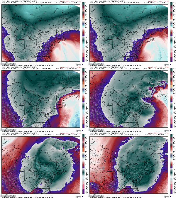
NOW, this IS HAPPENING! the Center of low pressure will use its self to form another low and swing back around in basically a circle over NY and New England - SO, NEW PRECIP FORMS, we get that moisture from the system interacting with that COLD air coming south, and PRESTO! BOO YA! Rain and Snow arrives tomorrow after a break in the precip today. I DO NOT EXPECT MAJOR ACCUMULATIONS, MAX 1-3" IN HIGH ELEVATION AREAS, BUT DO NOT BE SURPRISED IF THERE IS SNOW ON THE GROUND!
SO, FORECAST
TONIGHT - A LULL IN PRECIP, CLOUDY SKIES w/ some showers AS THE ORIGINAL LOWS SPINS UP INTO NEW ENGLAND. Some Rain/Snow/Sleet may still stick around in the Taconic Hills, Catskills, Putnam County up there South of Albany. Lows in the mid 30's...Winds 10-20mph
WEDNESDAY - Rain and Snow showers throughout the day, low to mid 30's. Winds back up there 20-30mph FOLKS up north of OSSINING WILL HAVE A MUCH BETTER CHANCE AT THE SNOW ACCUMULATING 1-3" OR MORE.
FLOOD WARNING STILL UP AS RAIN MAY GET HEAVY TOMORROW!
WEDNESDAY NIGHT - CLOUDY, SOME RAIN/SNOW LINGERING CLEARING OUT LATE. Lows near 30*....
THURSDAY - Some lingering snowshowers in the morning possible, then cloudy as the storm moves out Highs in the mid 30's
FRIDAY - Partly sunny, storm will begin to move out finally Highs in the mid 30's.
HAVE A NICE NIGHT FOLKS!!!
NOW, ONTO THE STORM - In terms of the models, THERE WERE ALOT of problems with this storm, and its complexity and size...the MAIN issue was the warm air. None of the models saw it coming (Except the NAM) and what "it" was, was the fact that the storm was able to bring that warm air ALL the way north past Albany, West to Ithaca, and North to Portland, ME...This created a much bigger rain/ice event then expected, AND cut down those snow totals for many areas. Storm ALSO shifted EAST, causing the heaviest precip to move more OVER US, instead of Interior NY, NJ, and west of us.
SO, Otherwise, however, the system behaved as expected - NOW, WE STILL HAVE 2/3 MORE DAYS OF IT....ON AND OFF.
Now, I am happy that I can say I pointed this out a week ago when the storm initially came onto the models, and Dillon and I were in agreement with this, even as the system came through today - The REAL cold air (High Pressure System) would come on the STORMS heels, and behind it - not interact with it enough to cause a real SNOW event down here.
NOW, this IS HAPPENING! the Center of low pressure will use its self to form another low and swing back around in basically a circle over NY and New England - SO, NEW PRECIP FORMS, we get that moisture from the system interacting with that COLD air coming south, and PRESTO! BOO YA! Rain and Snow arrives tomorrow after a break in the precip today. I DO NOT EXPECT MAJOR ACCUMULATIONS, MAX 1-3" IN HIGH ELEVATION AREAS, BUT DO NOT BE SURPRISED IF THERE IS SNOW ON THE GROUND!
 |
| NAM 18z 850hPa showing temps invading (Blue/grey is COLDEST) |
SO, FORECAST
TONIGHT - A LULL IN PRECIP, CLOUDY SKIES w/ some showers AS THE ORIGINAL LOWS SPINS UP INTO NEW ENGLAND. Some Rain/Snow/Sleet may still stick around in the Taconic Hills, Catskills, Putnam County up there South of Albany. Lows in the mid 30's...Winds 10-20mph
WEDNESDAY - Rain and Snow showers throughout the day, low to mid 30's. Winds back up there 20-30mph FOLKS up north of OSSINING WILL HAVE A MUCH BETTER CHANCE AT THE SNOW ACCUMULATING 1-3" OR MORE.
FLOOD WARNING STILL UP AS RAIN MAY GET HEAVY TOMORROW!
WEDNESDAY NIGHT - CLOUDY, SOME RAIN/SNOW LINGERING CLEARING OUT LATE. Lows near 30*....
THURSDAY - Some lingering snowshowers in the morning possible, then cloudy as the storm moves out Highs in the mid 30's
FRIDAY - Partly sunny, storm will begin to move out finally Highs in the mid 30's.
HAVE A NICE NIGHT FOLKS!!!
 |
| NAM MSLP+PRECIP, showing reforming of the Low. |
No comments:
Post a Comment