Showing posts with label freezing rain. Show all posts

Tuesday, March 3, 2015

Tuesday Evening Winter Storm Update

Updated: 0030z/19:30/07:31PM
*****Emergency Alert for the Period NOW until Tomorrow Morning*****
Guys Obviously this front thump of snow has overachieved in everyway. Currently recording almost 5" at my house, and a friend in White Plains has the same recording. White Plains Airport is at 4.9" officially as of 7pm.
Please, please be careful - now we are changing over to an Ice/Freezing Rain/Sleet Mix and it will stay like this for the next SEVERAL hours before changing to plain rain around or after midnight.
Anymore Accumulations should be between 1-3" of this mess, maybe a bit more.
FORECAST
TONIGHT - ICE/freezing rain/sleet/snow continuing before changing over around midnight to rain. Additional Accumulations 1-3" if not more. Temps around freezing.
TOMORROW - Rain and dense fog, rain may be heavy at times in the morning, but doubtfull. The GROUND will be below freezing so WATCH out for Ice!!!!! GONNA be a really MESSY morning.
A lull in the precipitation as cold front comes through and storm pulls away, our second wave forming.
TOMORROW NIGHT - Rain turning to ice to all snow by midnight and continuing, temps in the mid to high 20's.
THURSDAY - Snow in the morning through afternoon tapering off in the evening. Could be significant accumulations. Temps in the high 20's.
FRIDAY - Frigid watch for rapid freezup highs in the low 20's.

FORECAST DISCUSSION
A rapidly deepening low pressure system will continue to move across Southern Canada and take over with rain after midnight tonight. As it pulls out tomorrow a wave will form off the bucket loads of moisture along the frontal boundary (cold/warm air) Where this frontal boundary will determine the exact trend of the heaviest snows, but it seems that the Arctic Air coming behind it will be enough to suppress the axis of heaviest precipitation along NYC to Philly. We would once again be on the northern edge of the heavy (ish) snows. Right now I am calling for 3-5" with a possibility of going down and up. Dillon thinks 1-2". What should be noted is that as the storm intensifies, much like today, the snow ratios will bump up especially from the air rapidly cooling. We can expect 12:1 ratios and maybe 15:1 if lucky. Also keep in mind that the heaviest snows are NYC to Philly - NYC is less then 30 miles away. It would really not take MUCH for us to get in the heavier snows again. An example is that Yonkers has a Winter Storm Warning for 4-8" of snow, and here in Irvington we have no warning and just 2-4" of snow. Not far to move!. however as of now this is the forecast. You could say Dillon scored a "coup" I still have my doubts though!
This second half of the storm should continue into Thursday afternoon and evening. Initial first call snow map is below.
Guys, even if we do not get 8-12" with the next batch of snow - it will be very icey, very dangerous tomorrow into Thursday afternoon. This is NOT a storm to take lightly, especially because of its long duration.
Ok thats it for now! Be back later if need be
 
smile emoticon

Monday, December 15, 2014

********MONDAY EVENING DISCUSSION***********


FEW POINTS OF DISCUSSION

-The Possibility of a potentially major storm is VERY MUCH in the realm of possibility for Saturday night into Sunday night (20-21st). SO KEEP AN EYE ON THE POSTS COMING FROM HERE, WE WILL HAVE THE LATEST UPDATES.

- AO/NAO/EPO/WPO/PNA ALL TANK AROUND 24TH-26TH SO IT SEEMS, WHAT DOES THIS MEAN? WELL ESSENTIALLY THAT WINTER WILL REALLY BE LOCKING IN - COLD, STORMINESS...MUCH LIKE THE PATTERN BACK IN NOVEMBER, BUT MORE SUSTAINED AND STORMY.

- ANOTHER POSSIBLE STORM, YES, Right on the heels of the possible Saturday-Sunday Storm we get ANOTHER for Christmas...Details still vague but the possibility, again DEFINITELY there!!!

- THE BLOCKING we have been waiting for (or at least I have) will begin to set up between and after the Sunday and Christmas storms, coinciding with the Oscillations/Teleconnections tanking! 


***********************FORECASTIC FORECAST**********************

TONIGHT - Highs in the HIGH 20's, clear

TUESDAY - Partly Cloudy skies over to all cloudy w/ showers developing in the evening and changing over to all rain in the night, MAYBE a bit of freezing sleet/ice for a bit but I am doubtful. Highs in the mid 40's, lows in the HIGH 30's. Areas in Northern NY, Southern NE...maybe even Boston could see some snow showers/light snow on the backside.

WEDNESDAY - BIG WARMUP! HIGHS NEAR 50*, Partly Cloudy

THURSDAY - Highs back down to high 30's, sunny.

FRIDAY - Highs low to mid 30's, sunny.

WILL GET TO WEEKEND LATER!

PICTURES

- EUROPEAN ENSEMBLE CONTROL RUN OF TOTAL SNOWFALL, IN NO MEANS A FORECAST JUST A GUIDE TO THOSE WHO COULD SEE SNOW. ENSEMBLE MEAN RUN ALSO INCLUDED


- EUROPEAN ENSEMBLE MSLP MAP FOR THE POSSIBLE SUNDAY STORM.


Wednesday, December 10, 2014

QUICK Morning Update on some SNOW today!

Latest data shows A BETTER chance for a 1-3" accumulation of snow for today/tonight into tomorrow for the 2ND HALF of the Nor'Easter.

Rain and Snow will develop with morning and change to ALL snow in the afternoon, probably a LIGHT 1-3" IF WE are Lucky, although the data says we are, there is still uncertainty with this....SO JUST A HEADS UP!

Have A GREAT DAY!


Tuesday, December 9, 2014

Tuesday Evening Update and Discussion on Storm

TUESDAY EVENING UPDATE/DISCUSSION


NOW, ONTO THE STORM - In terms of the models, THERE WERE ALOT of problems with this storm, and its complexity and size...the MAIN issue was the warm air. None of the models saw it coming (Except the NAM) and what "it" was, was the fact that the storm was able to bring that warm air ALL the way north past Albany, West to Ithaca, and North to Portland, ME...This created a much bigger rain/ice event then expected, AND cut down those snow totals for many areas. Storm ALSO shifted EAST, causing the heaviest precip to move more OVER US, instead of Interior NY, NJ, and west of us.


SO, Otherwise, however, the system behaved as expected - NOW, WE STILL HAVE 2/3 MORE DAYS OF IT....ON AND OFF.
Now, I am happy that I can say I pointed this out a week ago when the storm initially came onto the models, and Dillon and I were in agreement with this, even as the system came through today - The REAL cold air (High Pressure System) would come on the STORMS heels, and behind it - not interact with it enough to cause a real SNOW event down here.

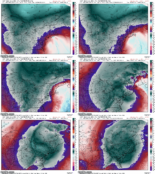
NOW, this IS HAPPENING! the Center of low pressure will use its self to form another low and swing back around in basically a circle over NY and New England - SO, NEW PRECIP FORMS, we get that moisture from the system interacting with that COLD air coming south, and PRESTO! BOO YA! Rain and Snow arrives tomorrow after a break in the precip today. I DO NOT EXPECT MAJOR ACCUMULATIONS, MAX 1-3" IN HIGH ELEVATION AREAS, BUT DO NOT BE SURPRISED IF THERE IS SNOW ON THE GROUND!


NAM 18z 850hPa showing temps invading (Blue/grey is COLDEST)


SO, FORECAST

TONIGHT - A LULL IN PRECIP, CLOUDY SKIES w/ some showers AS THE ORIGINAL LOWS SPINS UP INTO NEW ENGLAND. Some Rain/Snow/Sleet may still stick around in the Taconic Hills, Catskills, Putnam County up there South of Albany. Lows in the mid 30's...Winds 10-20mph

WEDNESDAY - Rain and Snow showers throughout the day, low to mid 30's. Winds back up there 20-30mph FOLKS up north of OSSINING WILL HAVE A MUCH BETTER CHANCE AT THE SNOW ACCUMULATING 1-3" OR MORE.

FLOOD WARNING STILL UP AS RAIN MAY GET HEAVY TOMORROW!

WEDNESDAY NIGHT - CLOUDY, SOME RAIN/SNOW LINGERING CLEARING OUT LATE. Lows near 30*....

THURSDAY - Some lingering snowshowers in the morning possible, then cloudy as the storm moves out Highs in the mid 30's

FRIDAY - Partly sunny, storm will begin to move out finally Highs in the mid 30's.


HAVE A NICE NIGHT FOLKS!!!

NAM MSLP+PRECIP, showing reforming of the Low.

Heavy rain moving North! - Morning Update

*********HEAVY RAIN, SOME ICEY RAIN MOVING NORTH, SNOW ON THE HORIZON*******

As the storm spins north it will tighten and intensify, and then stall over us the afternoon/evening. Expect heavy rain to continue, and some icey rain as well. Do not be surprised if some wet flakes fall as well! 

Getting more confident on a spread of snow wednesday night into thursday morning as the system loops around and the center of pressure reforms. MORE ON THIS LATER!

Folks to the North, in Putnam, up the taconic and into the catskills, DO NOT BE SURPRISED IF IT IS SNOWING, and POSSIBLY accumulating - this is a very elevation dependent storm!

Have a great day folks!