Showing posts with label hudsonvalley. Show all posts

Monday, December 15, 2014

********MONDAY EVENING DISCUSSION***********


FEW POINTS OF DISCUSSION

-The Possibility of a potentially major storm is VERY MUCH in the realm of possibility for Saturday night into Sunday night (20-21st). SO KEEP AN EYE ON THE POSTS COMING FROM HERE, WE WILL HAVE THE LATEST UPDATES.

- AO/NAO/EPO/WPO/PNA ALL TANK AROUND 24TH-26TH SO IT SEEMS, WHAT DOES THIS MEAN? WELL ESSENTIALLY THAT WINTER WILL REALLY BE LOCKING IN - COLD, STORMINESS...MUCH LIKE THE PATTERN BACK IN NOVEMBER, BUT MORE SUSTAINED AND STORMY.

- ANOTHER POSSIBLE STORM, YES, Right on the heels of the possible Saturday-Sunday Storm we get ANOTHER for Christmas...Details still vague but the possibility, again DEFINITELY there!!!

- THE BLOCKING we have been waiting for (or at least I have) will begin to set up between and after the Sunday and Christmas storms, coinciding with the Oscillations/Teleconnections tanking! 


***********************FORECASTIC FORECAST**********************

TONIGHT - Highs in the HIGH 20's, clear

TUESDAY - Partly Cloudy skies over to all cloudy w/ showers developing in the evening and changing over to all rain in the night, MAYBE a bit of freezing sleet/ice for a bit but I am doubtful. Highs in the mid 40's, lows in the HIGH 30's. Areas in Northern NY, Southern NE...maybe even Boston could see some snow showers/light snow on the backside.

WEDNESDAY - BIG WARMUP! HIGHS NEAR 50*, Partly Cloudy

THURSDAY - Highs back down to high 30's, sunny.

FRIDAY - Highs low to mid 30's, sunny.

WILL GET TO WEEKEND LATER!

PICTURES

- EUROPEAN ENSEMBLE CONTROL RUN OF TOTAL SNOWFALL, IN NO MEANS A FORECAST JUST A GUIDE TO THOSE WHO COULD SEE SNOW. ENSEMBLE MEAN RUN ALSO INCLUDED


- EUROPEAN ENSEMBLE MSLP MAP FOR THE POSSIBLE SUNDAY STORM.


Tuesday, December 9, 2014

Tuesday Evening Update and Discussion on Storm

TUESDAY EVENING UPDATE/DISCUSSION


NOW, ONTO THE STORM - In terms of the models, THERE WERE ALOT of problems with this storm, and its complexity and size...the MAIN issue was the warm air. None of the models saw it coming (Except the NAM) and what "it" was, was the fact that the storm was able to bring that warm air ALL the way north past Albany, West to Ithaca, and North to Portland, ME...This created a much bigger rain/ice event then expected, AND cut down those snow totals for many areas. Storm ALSO shifted EAST, causing the heaviest precip to move more OVER US, instead of Interior NY, NJ, and west of us.


SO, Otherwise, however, the system behaved as expected - NOW, WE STILL HAVE 2/3 MORE DAYS OF IT....ON AND OFF.
Now, I am happy that I can say I pointed this out a week ago when the storm initially came onto the models, and Dillon and I were in agreement with this, even as the system came through today - The REAL cold air (High Pressure System) would come on the STORMS heels, and behind it - not interact with it enough to cause a real SNOW event down here.

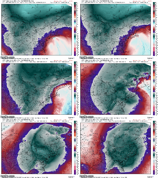
NOW, this IS HAPPENING! the Center of low pressure will use its self to form another low and swing back around in basically a circle over NY and New England - SO, NEW PRECIP FORMS, we get that moisture from the system interacting with that COLD air coming south, and PRESTO! BOO YA! Rain and Snow arrives tomorrow after a break in the precip today. I DO NOT EXPECT MAJOR ACCUMULATIONS, MAX 1-3" IN HIGH ELEVATION AREAS, BUT DO NOT BE SURPRISED IF THERE IS SNOW ON THE GROUND!


NAM 18z 850hPa showing temps invading (Blue/grey is COLDEST)


SO, FORECAST

TONIGHT - A LULL IN PRECIP, CLOUDY SKIES w/ some showers AS THE ORIGINAL LOWS SPINS UP INTO NEW ENGLAND. Some Rain/Snow/Sleet may still stick around in the Taconic Hills, Catskills, Putnam County up there South of Albany. Lows in the mid 30's...Winds 10-20mph

WEDNESDAY - Rain and Snow showers throughout the day, low to mid 30's. Winds back up there 20-30mph FOLKS up north of OSSINING WILL HAVE A MUCH BETTER CHANCE AT THE SNOW ACCUMULATING 1-3" OR MORE.

FLOOD WARNING STILL UP AS RAIN MAY GET HEAVY TOMORROW!

WEDNESDAY NIGHT - CLOUDY, SOME RAIN/SNOW LINGERING CLEARING OUT LATE. Lows near 30*....

THURSDAY - Some lingering snowshowers in the morning possible, then cloudy as the storm moves out Highs in the mid 30's

FRIDAY - Partly sunny, storm will begin to move out finally Highs in the mid 30's.


HAVE A NICE NIGHT FOLKS!!!

NAM MSLP+PRECIP, showing reforming of the Low.

Monday, December 8, 2014

Monday Evening Update and Discussion - FULL ON STORM MODE GUYS

OK GUYS WE ARE IN FULL ON STORM MODE
A MAJOR NOR'EASTER WILL BE AFFECTING THE AREA FROM LATE TONIGHT UNTIL WEDNESDAY NIGHT, POSSIBLY INTO THURSDAY EARLY MORNING.


Now, for the forecast! GUYS, AGAIN THERE IS A BUST POTENTIAL WITH THIS STORM, THIS FORECAST IS BASED OFF THE LATEST DATA AVAILABLE TO US, SO LOOK OUT FOR UPDATES!

*****FOR THE BULK OF THIS STORM, THE STORM WILL BE BRINGING TO MUCH WARM AIR OFF THE OCEAN TO ALLOW FOR REAL SNOW, HOWEVER, AND THIS IS VERY IMPORTANT
THE AIR IN THE ATMOSPHERE, WILL BE VERY COLD, AND THEREFORE PRECIPITATION THAT FALLS MAY NOT HAVE TIME TO MELT IN THE WARMER AIR NEAR THE SURFACE, GIVING THE HUGE POTENTIAL FOR ICE, SLEET, AND MAYBE SNOW - SO WATCH OUT, ESPECIALLY DEPENDING ON WHEN THE PRECIP GETS HERE TONIGHT!


TONIGHT - Rain Developing LATE, AND VERY LIKELY MIXING WITH ICE...Lows in the low 30's, a Northeast wind 10-20mph will bring in that cold air as well. 

TOMORROW (TUESDAY)- ITS SHOW TIME, HEAVY RAIN spreads throughout the morning and into the nighttime as the Center of the storm approaches and MAKES THAT CLASSIC SANDY LIKE HOOKED LEFT TURN INTO THE COAST!!! I WOULD NOT BE SURPRISED IF WE GET WET, HEAVY FLAKES, SOME ICE AND SLEET mixed in, as the air in the atmosphere will certainly be cold enough for the precip to not have a chance to melt possibly on the way down. Highs in the mid 30's, Winds 20-30mph possibly gusting up and over 40mph from the Northeast-NorthWest.

TUESDAY NIGHT - Rain will continue, start to let up, chance of some snow MIXING in, I do not think there will be much accumulation. Temps in the low to mid 30's.

WEDNESDAY - Rain showers/Steady light rain on and off. What is happening is the Low is going to reform around the center of low pressure and loop/pinwheel back around giving a second round of precip. NOW, it looks like it will get that COLD air more readily, and not the warmer ocean air, so WATCH OUT FOR SNOW MIXING IN. Temps again mid 30's Winds 10-20mph

WEDNESDAY NIGHT - Rain and Snow Showers/sleet/ice maybe. Temps near 30* Winds 10-15mph diminishing.

*****GUYS NEAR THE COAST, EXPECT BEACH EROSION AND GALE FORCE WINDS, FLOODING IS POSSIBLE ESPECIALLY IN LOW LYING AREAS*********

HAVE A GOOD NIGHT FOLKS!

WIND GUST MAPS - GUYS THAT 40-50MPH GUSTS IN OUR AREA!


STORM TRACK

EUROPEAN SNOWFALL OUTPUT - LIKELY TO CHANGE


Welcome to Weather in the Hud with Remy Mermelstein and Dillon Palmieri!

Welcome! Dillon and I have created this blog as another way for you to get our forecasts, discussions, maps and pictures and expand our horizon beyond Facebook. Our posts will be the same as on Facebook, and will include everything that we do on our FB Page. If you are new to us, you can go look at previous and current posts on our Facebook Page which can be found HERE. We will also begin the process of making a formal website soon, so look forward to updates about that. 

In addition to welcoming you to our new blog, I think it is a good idea to provide some background on who we are, and why you should listen to us about your everyday weather, as well as longer term weather and climate.

Remy (Me) - I am 16 and in 10th grade at Irvington High School in Irvington, NY. My love for weather has been around all my life, starting with my absolute obsession with winter and snowstorms since I was a toddler. In addition to weather, I pursue an active life in architecture, interning at a local architects office (Website can be found HERE) and doing many community projects, building, designing and landscaping. I am pursuing a pilots license as well, and my knowledge and love for weather helps greatly when flying. My weather page, Weather or Not in the Rivertowns with Remy Mermelstein has been up for about a year now, and I update it at least every other day or more with the latest in weather. I study weather extensively on my own time, and am extremely active in the forums on many weather sites, my favorite being Weatherbell where the knowledge of some of the worlds greatest forecasters are available to me, as well as the massive community of meteorologists, climatologists and pure hobbyists this world has. Dillon and I are also currently working with Joe D'aleo on Science Research involving correlations and effects between the NAO/AO/AMO/PDO...etc... Everyday brings a new realm of learning to us here at Weather in the Hud, and everyday we learn more. So thank you for joining us here to read our forecasts! And, as always, if you have suggestions, advice about our posts, or the weather and our forecasting PLEASE tell us - we are still students and we recognize that, and want to learn as much as we can. Thank you.

Dillon Palmieri – Hi! I am a sophomore at Irvington High School in New York. Like my colleague Remy, my obsession with meteorology started at a young age when I became fascinated by tornadoes at the age of four. From there, my interest in the field expanded to winter storms, severe weather, and finally grew enough for me to want to create my own weather forecasts. Starting last spring (2014), I began officially doing weather forecasts for the public in the Hudson Valley region with Remy on our Facebook page Weather or Not in the Rivertowns. Our popularity quickly grew into hundreds of followers as our forecasts were consistently accurate and provided detailed information that would otherwise not be provided for a specific area such as the Hudson Valley. I also am currently working with Joe D'Aleo, a very well-known meteorologist employed at Weatherbell on a science research project studying the effects of the AMO, PDO, NAO, and AO on global climate. I wish to thank you for visiting our site and please know we welcome any and all input from our followers to make our site better.

ONCE AGAIN! WELCOME TO WEATHER IN THE HUD WITH REMY MERMELSTEIN AND DILLON PALMIERI WE HOPE YOU ENJOY IT!